

FireDataCleanup
hotlinks
USGS WaTERDASHBOARD @usgs DSCOVR: EPIC _ Gallery : West Coast Wildfires NASA - LANCE - FiRMS Global Fire Map, Live MAps with KML - downloads
Ecostress gallery
@stateofcalifornia Did Lack of Cityhood hurt Altadena ? @latimes @datadesk @whitehouse
About One-third of Malibu Burned In The Palisades Fire. Where Does It Go From Here?
@nasa-jpl Latimes @datadesk made a doc @nasa its great firedata!
@datadesk related firedata @nasa-jpl @nasa-pds @nasa .pdf summerofresistance @cityoflosangeles

cartography
https://www.jpl.nasa.gov/missions/airborne-visible-infrared-imaging-spectrometer-aviris/ AVIRIS is the first full spectral range imaging spectrometer and dedicated to Earth Remote Measurements . . AVIRIS Flight Request Information - CLiCKHERE
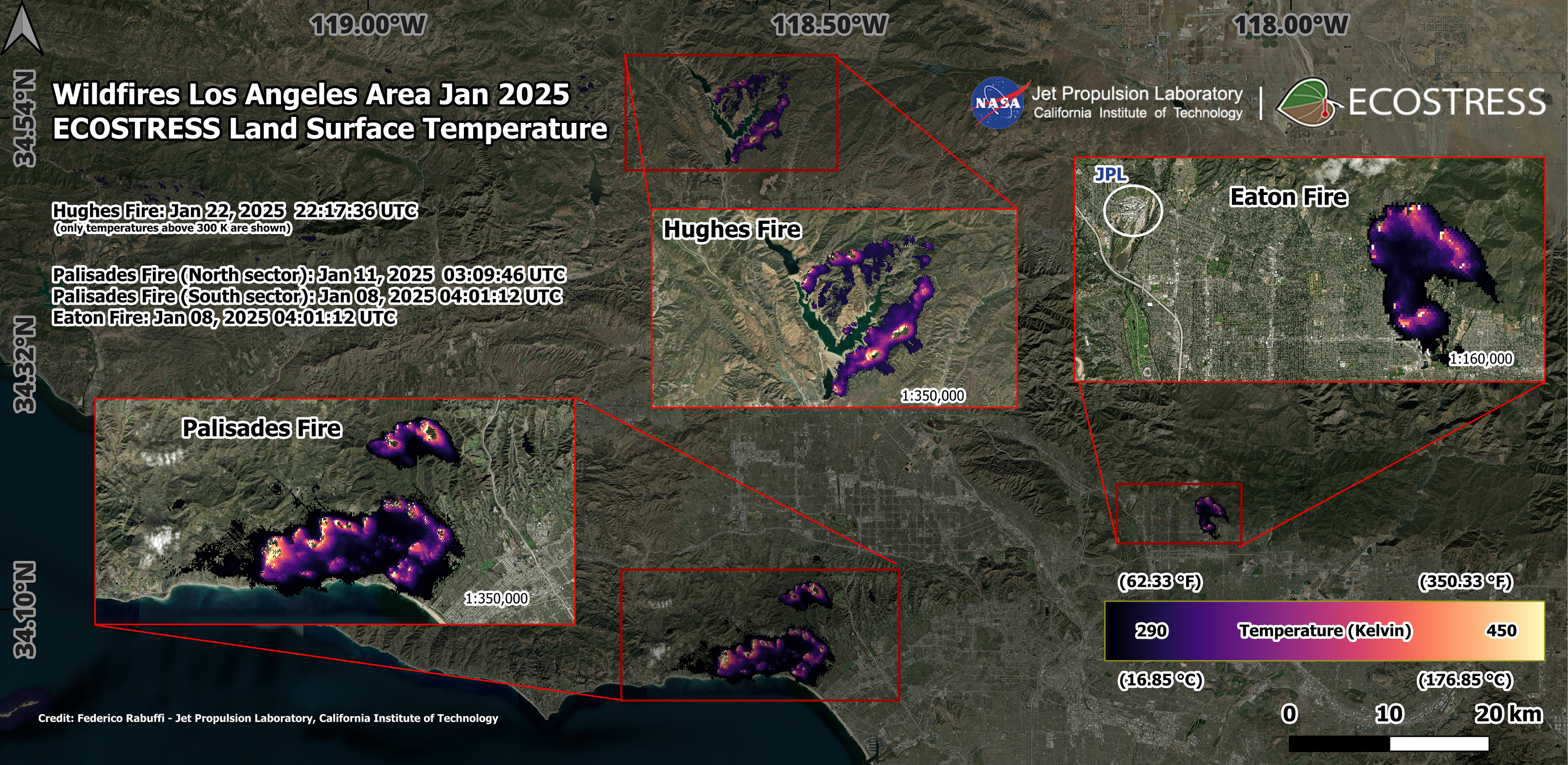
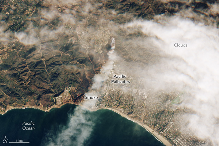
Overview Maps of 2025 Los Angeles Fires
![]() NASA’s Jet Propulsion Laboratory manages the EcoStress mission for the Earth Science Division in the Science MissionDirectorate at NASA Headquarters in Washington
NASA’s Jet Propulsion Laboratory manages the EcoStress mission for the Earth Science Division in the Science MissionDirectorate at NASA Headquarters in Washington
 @nasa-pds @nasa-jpl @nasa @whitehouse
JPL Fire Victim interview
@nasa-pds @nasa-jpl @nasa @whitehouse
JPL Fire Victim interview

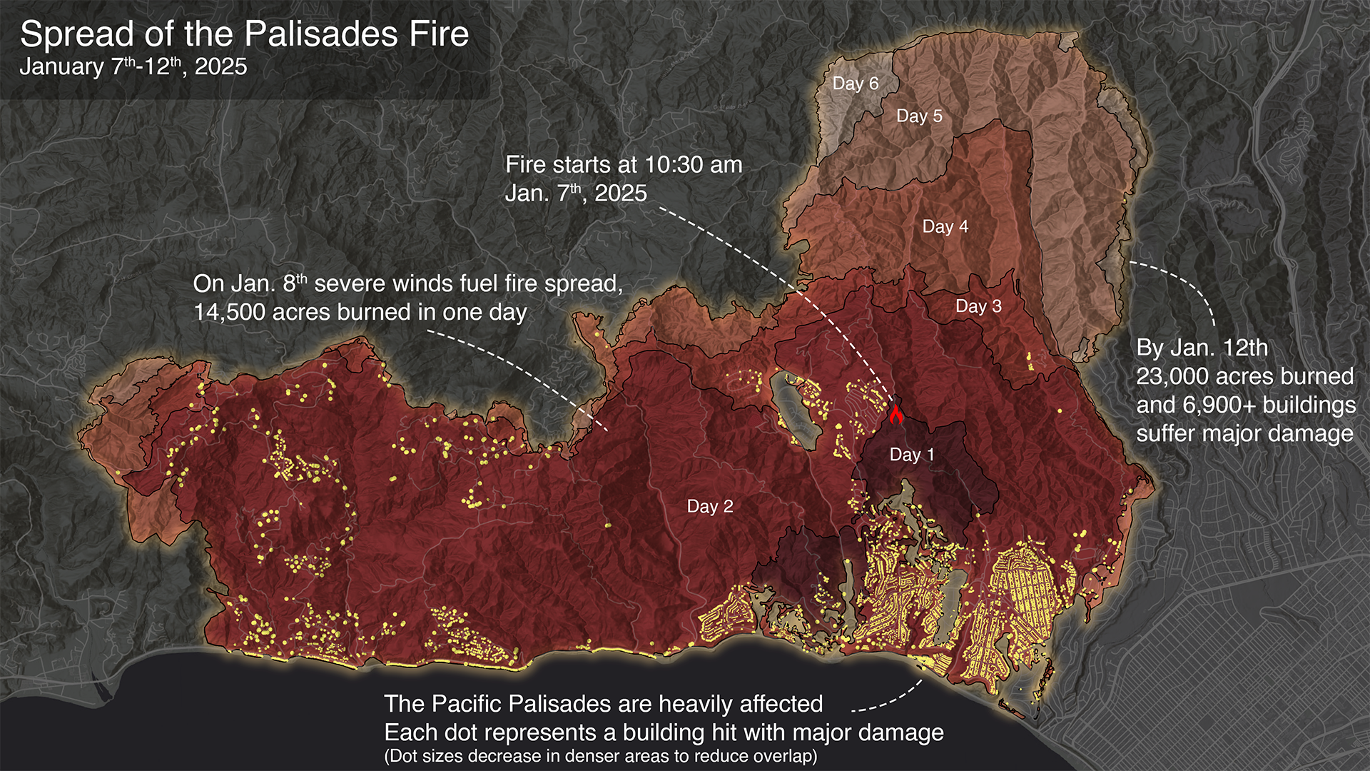
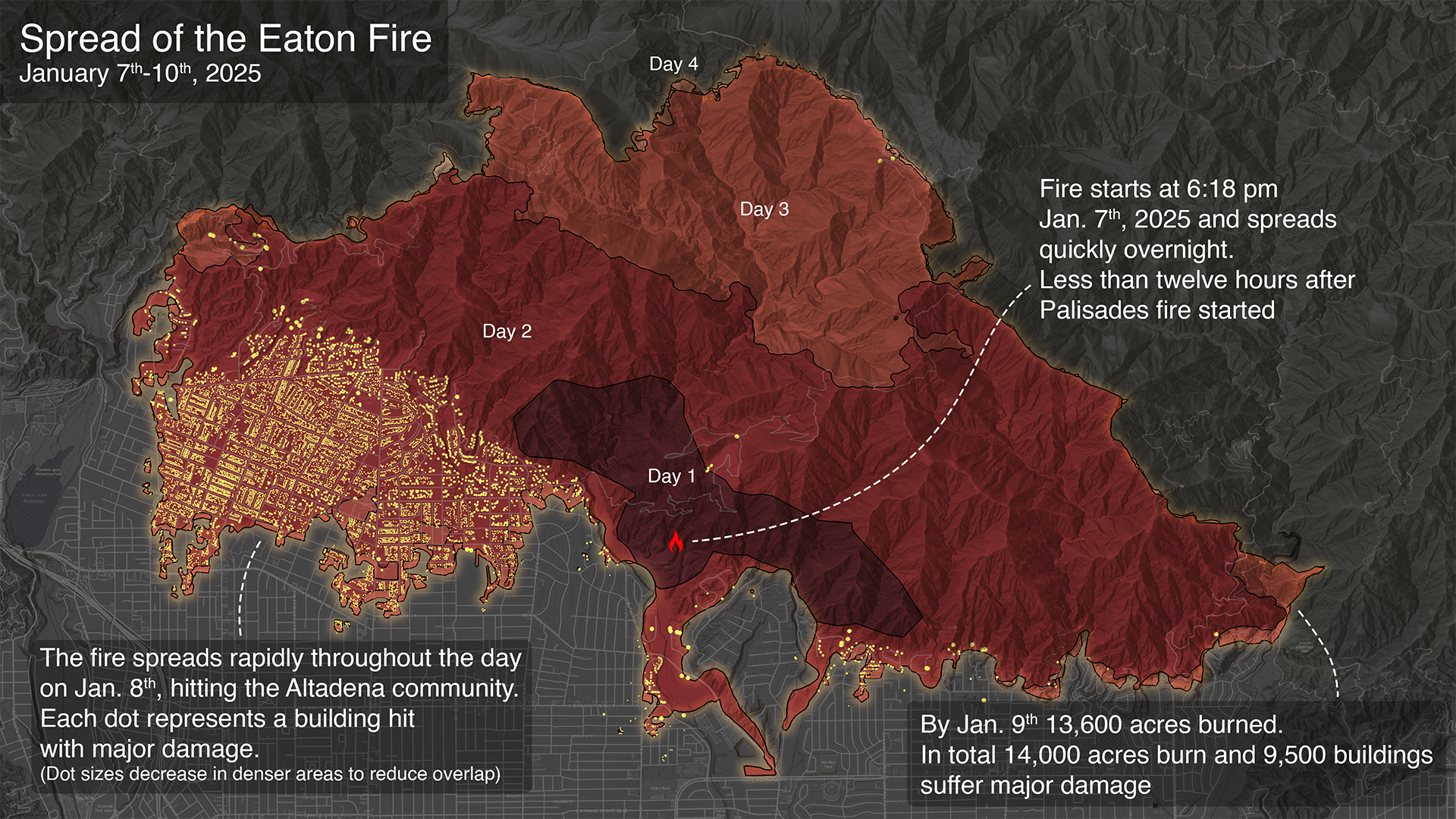
On January 7th, 2025, a series of wildfires started in the Southern California area, heavily affecting Los Angeles communities. The fires spread rapidly due to an abnormally dry year coupled with extreme winds raging at up to 100 miles per hour. Two of the fires, Eaton and Palisades, affected densely populated neighborhoods, spreading rapidly from structure to structure and combining to cause severe damage to over 16,000 homes and businesses. Released Friday, July 11, 2025
@stateofcalifornia @cityoflosangeles @nasa @dhs-gov
Fires Tear Through Los Angeles Powerful Santa Ana winds and dry conditions contributed to the rapid spread of several brush fires in the county. ReadMoreSeemORe
Palisades Fire reaches Brentwood, threatens San Fernando Valley @ktla youtube.com
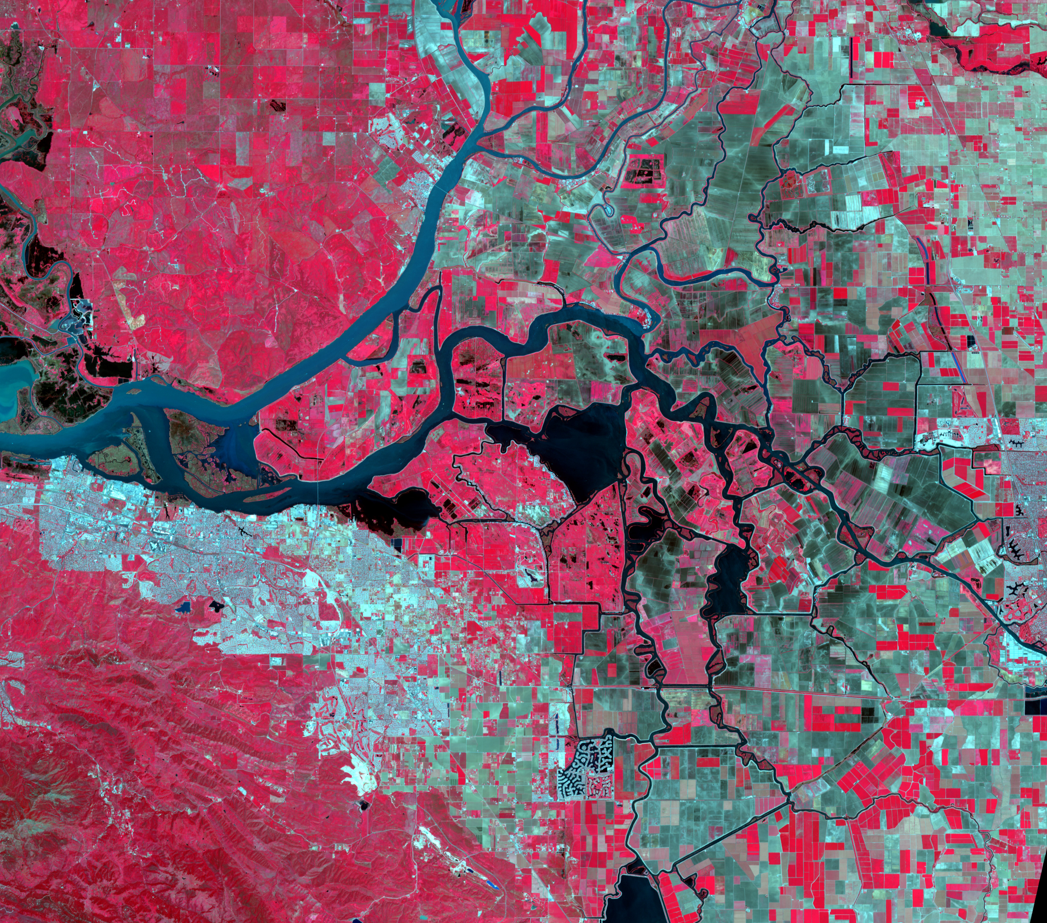
GRACE and GRACE-FO track California’s land water changes
NASA’s Gravity Recovery and Climate Experiment (GRACE, 2002 - 2017) mission, and its successor GRACE Follow-On (launched in 2018), map month-to-month changes in Earth’s gravity field resulting from the movement of mass, such as water, near the surface of the planet. This animation shows how the total amount of water (snow, surface water, soil moisture, and groundwater) varies in space and time, with the passage of dry seasons and wet seasons as well as with flooding, drought, and transport due to water management. Blue colors represent wetter than average conditions (relative to 2004-2010), while red colors represent drier than average conditions. The yellow line in the graph on the left shows the evolution of the long-term inter-annual variations for the area outlined in yellow on the map (note: the average seasonal cycle has been removed).
The Sacramento and San Joaquin River basins are outlined in yellow, and rivers and tributaries are shown as blue lines. The basins include California’s Central Valley, the most productive agricultural region in the U.S. Repeated drought conditions and increased water use in California have led to a long-term decline of terrestrial water, interspersed with above-average precipitation periods (e.g., 2015/2016, 2022/2023) that have allowed some recovery of the land water storage.
Credit NASA / JPL
A view of the #EatonFire behind @NASAJPL Flight Projects Center. It feels like Armageddon around here pic.twitter.com/pPWJ0B2rIB
— Royce (@RobRoyce_) January 9, 2025
### Wildfires in Los Angeles, California Image captured on Jan 8, 2025 ECOSTRESS Data Incorporated Into New Wildfire Response Tool

Scanned Articles
EatonCanyon UpDates
files :: Wiki :: TALK How NASA’s Infrared Imaging Uncovered the True Extent of Eaton Fire Devastation
Bass fires the L.A. fire chief, but her own smoldering political crisis is far from over @datadesk LA Mayor Karen Bass facing recall effort over handling of Palisades Fire

🇺🇸 #LAFires #CaliforniaFires #Arson #DEW #LandGrab #DirectedEnergyWeapons #WildFires #PalisadesFire #LosAngelesFires #California #LosAngeles #Malibu #SmartCity #Genocide
— 𝕁𝕒𝕕𝕖𝕕 (@Jaded42358177) February 23, 2025
Commie LA Mayor Karen Bass ‘Leaked Phone Call’
‘Read In Between The Lines…You Will Understand Soon pic.twitter.com/4ruylR9J02
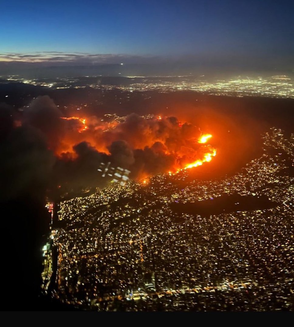
photo -@JackQuillinTV

Tools
Global Human Built-up And Settlement Extent (HBASE) Dataset From Landsat
EatonCanyonFam

@datadesk do you work for @nooa or @nasa @nasa-jpl @whitehouse or are you repackaging the data im not meddling, i just dont want to talk to strangers irl… -rashard
datadesk/nasa-wildfires - https://palewi.re/docs/nasa-wildfires/ Download wildfire hotspots detected by NASA satellites and the Fire Information for Resource Management System (FIRMS) @noaa -wildfires https://github.com/`your_account_name/yourfork.git +
= ![]() <~ your files inside! Thats MyBinder https://mybinder.org/
<~ your files inside! Thats MyBinder https://mybinder.org/
![]()
interruptions, blocks, confusion
@stateofcalifornia @cityoflosangeles @nasa @dhs-gov
DOXXED FOR THIS DATA
🚫 Sorry, this post was removed by Reddit’s filters.
https://svs.gsfc.nasa.gov/5568/ Visualizations by: https://svs.gsfc.nasa.gov/5558/
Visualizations by:
Scientific consulting by:
Doug C. Morton @nasa @cityoflosangeles @stateofcalifornia @atfweb
Spread of the Palisades and Eaton Fires - January 2025
byu/Dizzy-Decision-2115 innasa
https://t.co/yRYjz7ac5K @SpaceForceDoD #HappyEaster2025 @normani @BlackGirlsCode @USSF_SSC https://t.co/i14IpyLUXk https://t.co/FjwlsLQ5TT @_FloMilli @NASAJPL @LACityView35 lets correct annie, it's old 1937 @LACo_DPSS @hot1079atl pic.twitter.com/a2gsaDa22N
— ricoThaka (@RicoThaka) April 19, 2025
#GM @NASAJPL @CAL_FIRE @LACityCouncil @LADWP , @ISS_Research is telling us we have #PalisadesFire ! #morninBae @normani the shitty film crew left a light shining like #AlBundyShoW
— ricoThaka (@RicoThaka) February 11, 2025
@latto! @lafd
https://t.co/R4H8mOPoPs: pic.twitter.com/9S5ds0CTp9
JRE SUSPICIOUS Apollo 11 Post Flight Press Conference Apollo 11 Press Conference APOLLO 10 MISSION “GREEN LIGHT FOR A LUNAR LANDING” 1969 NASA FILM 42864 1966 MIT TV SHOW “SCIENCE REPORTER” RETURNING FROM THE MOON APOLLO PROGRAM 77454 LANGLEY Impact Basin (Building 1192)
@blackgirlscode Sim City 2000
